Haute Route in 7 Days : Chamonix to Zermatt Glacier Guided Trek
Experience the legendary Haute Route glacier trek from Chamonix to Zermatt, one of the most iconic alpine journeys in the world. Guided by IFMGA professionals, you’ll cross glaciers, stay in high-mountain huts, and link Mont Blanc to the Matterhorn on a 7-day high-alpine adventure.


Mountaineering boots

Warm hat

T-shirts

Thermal underwear

Neck gaiter (Buff)

Long sleeve shirt

Shorts

Fleece or woollen layers

Light puffer jacket

Windproof and waterproof jacket

Windproof and waterproof trousers

Thin gloves with leather palms for better grip

Gaiters

Sun hat

Hiking trousers

Warm gloves

Ice axe

Climbing harness

Telescopic poles

Climbing helmet
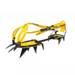
Crampons


